Sustainable land is key to the future health of the Potomac River and its inhabitants. While a significant portion of the land in the Potomac region is considered protected, population growth and the infrastructure to support it are paving over river friendly forests. Man-made surfaces like roads, housing, and parking lots are increasing, while forest coverage continues to decline.

Previous Grade: C+
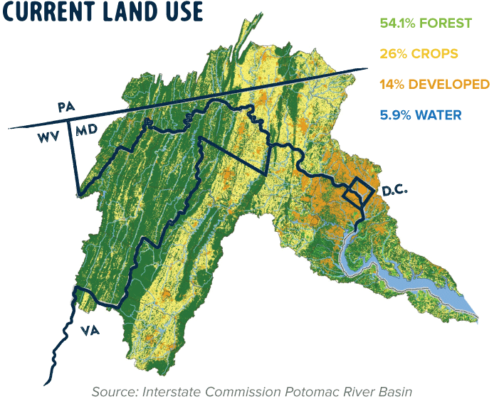
According to the most recent update to the National Land Cover Database in 2011, most land in the Potomac River region is forested (54.1 percent). The proportion of land cover by type remains fairly consistent with the previous update in 2006; however, it should be noted that known population growth in the region is likely fueling new development, particularly in rural-suburban areas of Loudoun County, Virginia, and Frederick County, Maryland.
The region has seen a slight increase in developed land and a decrease in forest and cropland. Pollution from urban runoff has been increasing over the last decade and is directly correlated to newly developed acres. The current land use grade is tied to the percentage of land that is forested in the Potomac Watershed. An update to the National Land Cover Database is expected to be released in 2016.

Previous Grade: N/A
The health of the Chesapeake Bay rests on the ability of our cities to responsibly protect local waters and embrace river friendly development. Stripped of most natural land cover, urban areas are a top source of polluted runoff to local rivers. Rapid population growth and the infrastructure to support it threaten to exacerbate the problem as sprawl replaces forests with parking lots, plazas, and roads.
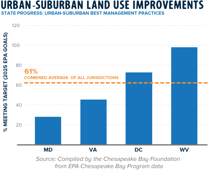
Progress in the implementation of Best Management Practices (BMPs) on urban and suburban lands varies widely by state in the Potomac region. In 2013, West Virginia reported meeting 98.1 percent of its 2025 federal BMP implementation goals* on urban and suburban lands, compared to 72.7 percent in Washington, DC, 45.3 percent in Virginia, and 28 percent in Maryland.
The grade for urban and suburban land use reflects the states’ reported progress (combined average of 61 percent) towards meeting the 2025 federal pollution reduction goals through BMP implementation.
*As part of the regional Chesapeake Bay cleanup plan, states and the EPA established pollution reduction goals to restore local rivers and the Bay back to full health. Embracing a quantitative approach, each state in the Bay region created Watershed Implementation Plans (WIPs) and set target goals to achieve significant pollution reductions by 2025.

Previous Grade: N/A
The region’s agricultural lands remain the single largest contributor of pollution to the Potomac River and Chesapeake Bay. Policies that ban phosphates in fertilizers and promote Best Management Practices (BMPs) on farmlands are helping to change that; pollution from agriculture is declining in the Potomac River.
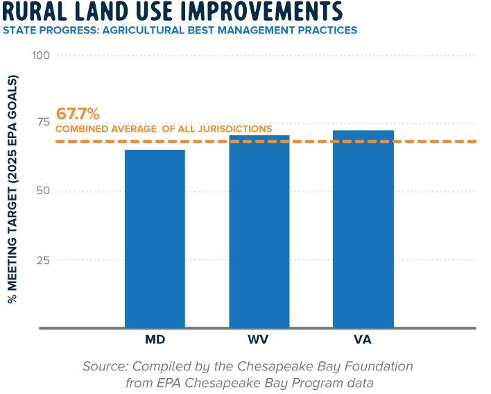
In 2013, Maryland, Virginia, and West Virginia reported meeting at least 60 percent of their federal 2025 BMP goals* on agricultural lands. Among the three states in the Potomac region, Virginia is the closest to meeting its BMP implementation goals (72.2 percent).
The grade for rural land use reflects the states’ progress (combined average of 67.7 percent) towards meeting the 2025 federal pollution reduction goals through BMP implementation.
*As part of the regional Chesapeake Bay cleanup plan, states and the EPA established pollution reduction goals to restore local rivers and the Bay back to full health. Embracing a quantitative approach, each state in the Bay region created Watershed Implementation Plans (WIPs) and set target goals to achieve significant pollution reductions by 2025.

Previous Grade: A
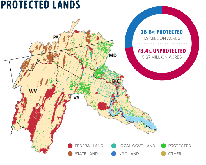
According to a 2013 US Geological Survey (USGS) report, 26.6 percent of land in the Potomac River region, or 1.9 million acres, is protected. The number of acres protected has increased since 2011, when 1.8 million acres of land (25 percent of the region) was protected.
Though more needs to be done to save river friendly forests and habitat, land protection efforts in the Potomac region are to be celebrated. The EPA established a conservation goal of 20 percent protected lands for the entire Bay area; the Potomac region is exceeding expectations by protecting 26.6 percent of the land in the Potomac Watershed.